|
 Langaran River is located in the northeastern part of Mt. Malindang, a mountain range that
became a National Park in 1971 by virtue of Republic Act No. 6266.
Langaran River is located in the northeastern part of Mt. Malindang, a mountain range that
became a National Park in 1971 by virtue of Republic Act No. 6266.
The stretch of Langaran River is under
the jurisdiction of four political entities or municipalities, namely; Concepcion, Calamba,
Lopez Jaena, and Plaridel. The barangays upstream (Singalat, Mamalad, and Bonifacio), were
inhabited predominantly by indigenous people called the Subanons while those in the downstream
(Catarman and Tipolo) were inhabited by a mix of migrants from all over the Philippines and
non-migrants.
The river plays a vital role in the economy of the
surrounding municipalities. Aside from being the domestic abode of many communities,
vast farmers are dependent on the irrigation waters from the three dams built along it.
The upstream communities are predominantly Subanons
while downstream communities are a mixture of long-time residents and migrants
from all over the country. Farming is the main occupation. The river is
the center of the family�s domestic activities. Fishing, using different
methods, is a major activity from upstream to downstream but is not considered a
source of income. Nevertheless, illegal fishing methods such as the "tubli"
(Derris root extract), "kuryente" (mild current) and pesticides in
the guise of tank and hand washing are rampant.
Environmental State of the Langaran River
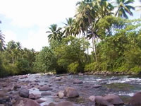 The river is shallow and wide, and the water turbid and the trees are very few.
According to residents of the communities, there was a time when the river was narrow
and deep and fishery resources were very abundant; there were even claims of crocodile
sightings from Catarman. The residents mentioned a number of factors that affected
the status of the river. These were illegal fishing activities (e.g., tubli and use
of the pesticide decis, "kuryente"), absence of trees in the bank, (illegal)
logging activities in the uplands, quarrying, irrigation, throwing of domestic and
municipal wastes into the river, extraction of water by the National Waterworks and
Sewerage Authority, and natural phenomena like landslides and floods.
The river is shallow and wide, and the water turbid and the trees are very few.
According to residents of the communities, there was a time when the river was narrow
and deep and fishery resources were very abundant; there were even claims of crocodile
sightings from Catarman. The residents mentioned a number of factors that affected
the status of the river. These were illegal fishing activities (e.g., tubli and use
of the pesticide decis, "kuryente"), absence of trees in the bank, (illegal)
logging activities in the uplands, quarrying, irrigation, throwing of domestic and
municipal wastes into the river, extraction of water by the National Waterworks and
Sewerage Authority, and natural phenomena like landslides and floods.
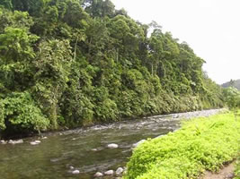
The riparian areas near the headwaters are relatively
rich in biodiversity and are a refuge for many endemic plant and animal species. The
water is clean, however, the pressure on the river and its riparians is increasing.
Cutting of trees continue and there is no visible effort to sustain the remaining
biodiversity and to rehabilitate the degraded parts. In contrast, the riparians
downstream are already degraded and the waters are already poor. The high pressure
from agricultural activities continues to threaten the state of biodiversity and the
environment.
|